

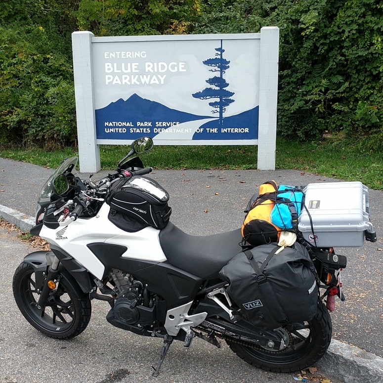
This past September, I took a trip I’d been looking forward to since deciding to get a motorcycle. I was determined to ride the length of Skyline Drive, the Blue Ridge Parkway (BRP), the Cherohala Skyway, and US 129, a.k.a. the Dragon. I was familiar with a good part of the route, as the prior year (with only five months riding under my belt) I rode Skyline Drive and the BRP to Asheville, NC and back after spending the weekend enjoying some truly excellent beers and good times in AVL with my family. On that trip I spent one night in Roanoke on the way down and back, crashing on a friend’s couch and the weekend at a hotel. This year I planned to camp four of the six nights, on the way down and back and stay in a hotel for two nights in Cherokee, NC. Because of the different approach, I needed to prepare and pack a bit more comprehensively.
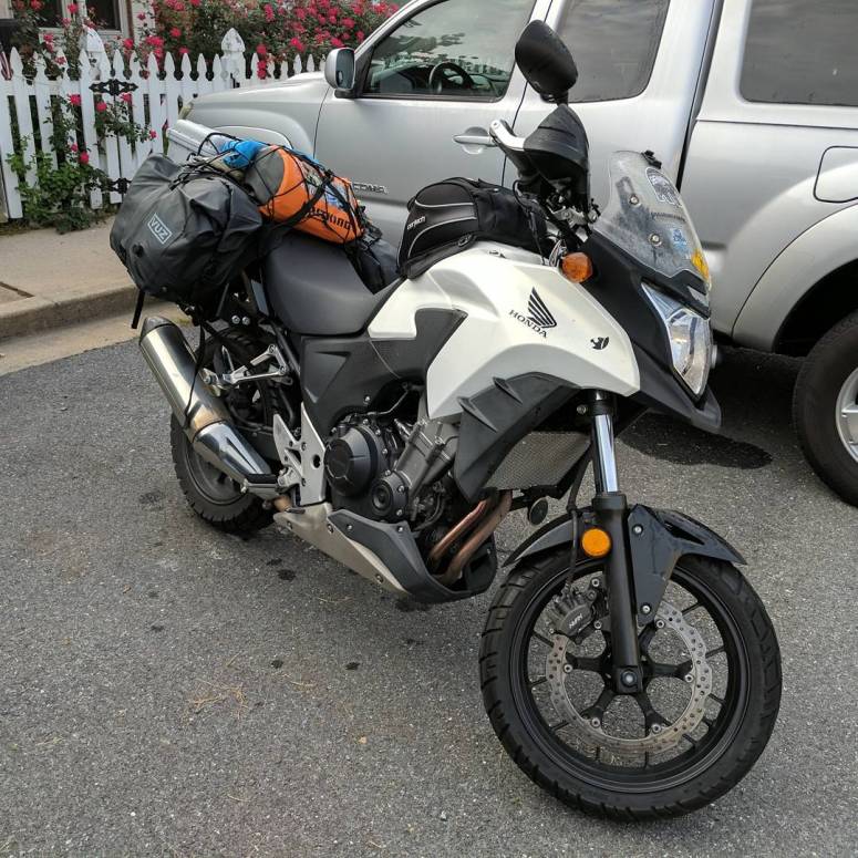
Planning, preparation, and packing started months before. I would of course be on my CB500X, but I had a lot more to think about compared to the year before. I definitely needed to up my game in terms of luggage; a dry duffel bag strapped to the rear seat, a tank bag, and small hydration pack sufficed for that trip, but would not do to hold a week’s worth of equipment and supplies. I initially hoped to use soft saddlebags without side racks or supports, but I was not confident that the bags could be kept off the rear wheel so I ordered racks from Rally Raid in England. I did quite a bit of research, got some awesome advice from Stephen Grasso at the Cafe Racer Podcast regarding what to pack, and decided on the equipment I would use. Choosing where to stay was the next hardest step, I ended up camping at National Parks Service campgrounds as a good balance of price and amenities, and chose a hotel in Cherokee. Planning a route was relatively easy after choosing where to stay. I did plan each day of riding using Rever, which allowed me to estimate the amount of time and distance I would be riding each day. Based on that info, I could also decide on where I would like to stop and explore as well.
Day 1 – Brunswick, MD to Peaks of Otter
I had packed my bags, tested my load out, and topped off the gas tank the day before; Sunday morning all I needed to do was load up the bike and say goodbye to my wife, son, and dog. My house is about an hour from the northern end of Skyline Drive in Front Royal, VA. The drive there was uneventful but I started to get excited as I pulled up to the gate and paid my entry fee. After getting rolling again I proceeded at a relaxed, but enjoyable, pace; traffic was relatively light, there seemed to be less RVs than the year before. I made 2 stops on Skyline Drive, Big Meadows (mile 51) for gas and then at Riprap Overlook (mile 91) for lunch.

After lunch, I finished out riding Skyline Drive and took a short detour to Afton, VA for a six pack of Full Nelson from Blue Mountain Brewery. I had stopped there the year before for lunch and can definitely attest they are an excellent choice for lunch and/or camp beers. I stowed my six pack of cans in a saddlebag and headed back to the start of the Blue Ridge Parkway.
The start of the BRP was was a continuation of the day’s earlier riding, I took a relaxed but enjoyable pace. There were some sections of construction where the road was moderately to very gravelly which necessitated much slower speeds but where I was very happy to have Shinko 705s wrapped on my wheels. As I passed the Otter Creek campground (mile 60) I noticed a bright yellow Saturn Sky receiving a performance award. A few miles later I stopped at the James River visitor center (mile 63); the driver and his friend in a red Corvette pulled in at the same stop and I overheard that his ticket was for 15 MPH over the limit (60 in a 45). The ranger only gave him the ticket because they clocked the Corvette at 50. I made a mental note to keep my speed at 55 or below and continued on to the Peaks of Otter campground (mile 86). The check-in at the campground was already closed for the evening when I arrived, but it was not difficult to locate my reserved site, set up camp, and enjoy some freeze dried pad thai and cold beers.

Day 2 – Peaks of Otter to Linville Falls
The next day started a little later than I would have liked, the first night sleeping away from home is always a little rough for me. This may have been aggravated by the rustling sounds of woodland creatures I heard several times through the night and thoughts of the food bag in the vestibule instead of the bear bin a dozen yards away. After breakfast I took some photos of camp and then packed up to get on the road.

Hitting the road started with checking out of the campground. I was informed by the ranger on duty that my particular campsite was the most popular for sighting bears. Another note to self – use the goddamn bear bins. Riding was relatively similar to the first day, a relaxed pace with more than a few miles of roads in various state of resurfacing. At one point I noticed a yellow RV trailer with Quebec plates I had seen on Skyline Drive was clearly on the same route as I was and had no intentions of letting anyone enjoy the road at any pace but theirs. Being a weekday, overall traffic was lighter, however there seemed to be a lot less willingness to be passed. Every car I passed accelerated as I did so. My first stop of the day was at Explore Park (mile 115), near Roanoke; this park currently has some hiking trails but has very interesting plans to become a full featured campground and vacation destination. I would really like to take my family there when it is built out fully. As it sits now they have a visitor center with a Blue Ridge Parkway Museum and large topographical model of the parkway, which is very cool and really puts the elevation changes into perspective. While there, I asked where a nice place to stop for lunch would be and was told that Smart View (mile 155) would offer a great place to relax.
After lunch I stopped in Floyd, VA (mile 160) to fuel up and did a quick mileage calculation, the CB500X impressed with 70 MPG. That combined with the range from a 4.6 gallon tank usually means just one fill up a day. The next stop was at Mabry Mill (mile 177), where I wasn’t able to stop the year before as I was trying to make time rather than enjoy the journey. I really enjoyed walking around to see the mill, reading about the history, and shoving a generous serving of ice cream in my mouth. Also, the Mabry Mill restaurant has WiFi, which is nice because cell service along the Parkway is definitely worse than I remembered.

The rest of the afternoon was more relaxed riding and I pulled into Linville Falls campground (mile 317) just before sunset. Setting up camp at Linville Falls was relatively uneventful, but as I was finishing up three gentlemen on bikes showed up and started setting up camp as well. I ate, took my notes for the day, cracked a beer, and then started schmoozing. It should be noted here that Full Nelson tastes pretty good even warm. It was good talking to other riders on a similar trip, they had started from the south and were on a Moto Guzzi Stelvio, Honda NC700X (with DCT), and a BMW F650GS. After chatting for a while, we all retired to our tents for some sleep. My campsite was immediately next to the Linville River and sleep came easier than the night before.
Day 3 – Linville Falls to Cherokee, NC
This was an interesting day. It started with a 2 beer hangover and squinting while I struggled to boil water for breakfast. Stay hydrated folks, you sweat more than you think on the bike. Luckily I remembered what sunglasses were and I was able to relax for a little while.


After packing down some coffee, freeze dried food, and plenty of water; I packed up camp, said farewell to my fellow moto campers and hit the road. First stop of the day was the Museum of North Carolina Minerals (mile 331) in Spruce Pine, NC. It’s not the largest museum, but very informational and plenty of hands on exhibits. This would be a great place to bring kids and family to learn more about the mountains the parkway travels over and the geology of the rest of the state. Before leaving Spruce Pine, I topped up on fuel and headed to Little Switzerland on NC 226A, a.k.a. the Diamondback. Before tackling the entire loop, I got some lunch at the Switzerland Cafe and General Store. I’m not sure whether it was any one part or the combination, but a french dip, chocolate eclair, and excedrin resolved the rest of the hangover and I was ready for some serious twisties.

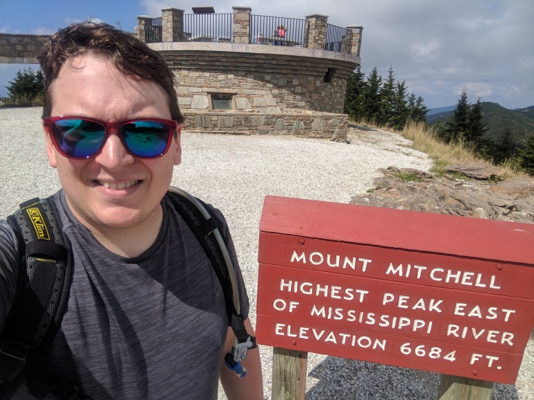
North Carolina 226A and 226 form a loop that is about 30 miles long and is an obscene amount of fun. The pavement is very well maintained and the switchbacks just beg to push the bike harder with every turn. After an hour of grinning, I headed further down the BRP to Mount Mitchell. Hurricane Irma had blown through the week prior and the section between Mount Mitchell (mile 355) and the Folk Art Center (mile 382) was still closed for cleanup. I was still able to visit the summit of Mount Mitchell and enjoy a much better view than fog and heavy cloud cover of the year prior.
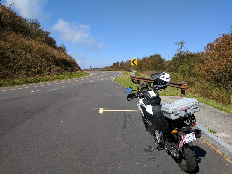
While I was enjoying the sunshine at the summit, I noticed a large bus type RV from Texas towing a Jeep Compass I had passed earlier pull in and leave the parking area. I decided to take a little more time at the summit in the hopes they would have a long lead in front of me in the event they didn’t stop somewhere else on the route to Asheville. Because of the closure, I had to backtrack a bit to NC route 80 (mile 344). NC 80 is also known as the Devil’s Whip and is every bit as intense as NC 226A if not more. It was a detour that ended up being a load of fun, at least until I caught up to the Texan land barge heading down the road at 11 MPH and doing it’s best to evaporate it’s brake pads. It passed several pull offs or other areas where it could have let the growing train of smaller vehicles by, it seems the yellow Quebecois motherfucker of the first two days had been replaced. I eventually made it to I-40, slabbed it to the main Blue Ridge Parkway Visitor Center (mile 384), and kept on rolling down the BRP. It seemed like no time and I was at the highest point on the parkway (mile 431).

From there, it was about 40 miles to the Rolling Hills Lodge in Cherokee, NC. This day’s ride had more wildlife than I had seen on the days prior, turkeys and deer were plentiful on the BRP, but on my way into Cherokee I saw a wild elk for the first time. A bull was grazing just where the parkway ends and I had no idea those things were so huge. After checking in, I got a bite to eat, took a much needed shower, and settled in to a good night’s rest.
Day 4 – Cherohala Skyway – US 129 – NC 28
The day had come to ride fabled roads which were no small part of my decision to take this trip. I started the day with coffee from Qualla Java and continental breakfast from the hotel. During breakfast I chatted with a few other visitors and quickly learned most people had no interest in anything other than the casino. While I was there for riding; the scenery and mountain beauty was a huge part of my experience. I also planned to visit the Museum of the Cherokee Indian to learn more about the culture of the Cherokee people, on who’s reservation I was a guest.

After breakfast I hit my chain with a fresh coat of lube and headed off to do some riding. Robbinsville, NC was a little further than I had expected from the hotel, but wasn’t bad at all. After reaching the Skyway, I was pleasantly surprised to find the pavement quality was immaculate. It was nothing but smooth grippy curves for 18 miles to the TN line where the pavement was older, but still pretty nice. I also for the most part had the road to myself, I saw only a few Miatas, NPS trucks, and other motorcyclists the entire 45 mile length of the Skyway.
At the western end of the Skyway I turned north up TN 360 which continued to be a pretty fun road even though there was a bit more company on the road. Temperatures gradually increased as I completed the loop around to US 129 and I was really glad to have my hydration pack with me; being able to pull over, drink, and jump back on the road quickly was very nice. I knew I was approaching the best part as I started to be joined by more motorcycles and the road signs started warning of curves and limitations for large vehicles. Once the switchbacks started it seemed like they wouldn’t stop. The camber in the curves was some of the most extreme I’ve seen. It was like the road was designed as a race track. Other drivers and riders on the road were extremely courteous and used pull offs to allow faster traffic to pass. The fun was briefly tempered, however, as traffic was stopped for a bit to allow an ambulance to assist a rider of a R1S that had gone down. The dragon is truly the most physically exhausting and intense road I’ve ever ridden. It was also interesting to have photographers at corners on a public road, but I’m happy there were as I was able to buy some excellent pictures from Killboy.com.
I continued down US 129 for a bit before I turned around and stopped at Deal’s Gap Motorcycle Resort and The Tail of the Dragon for lunch, a few pictures, and souvenir shopping.
After that it was down NC 28 back towards Cherokee which was a great ride as well. Within about 3 miles of the hotel one of the scattered thunderstorms which I had managed to dodge throughout the day finally caught me and I got a little wet. I pulled into the hotel, hung my jacket up to dry and walked over to the Museum where I unfortunately discovered it closed 2 hours before Google Maps indicated. Instead I checked out Qualla Arts and Crafts, a co-op for displaying and selling arts and crafts of the Cherokee. I was able to learn about the history of the co-op and how important a role it plays in keeping Cherokee traditional art alive. Then I had a pretty tasty bacon cheeseburger and washed it down with the last two Full Nelsons which were once again ice cold.
Day 5 – Cherokee, NC to Linville Falls
Getting up to leave was definitely more difficult than I imagined, but I got everything packed up, grabbed a bite, checked out, and hit the road pretty early. First stop of the day was at the Wheels Through Time Museum in Maggie Valley, NC. I arrived around 10 AM and took about 2 hours to peruse the entire museum. It’s really incredible how far American motorcycles have evolved over the years. I took a ton of photos and had a great time. All of the docents working there are incredibly knowledgeable and passionate about the machines on display. One in particular, Andy, was really great to talk to; in between stories about exhibits, he told me about his plans to complete the Trans-America Trail on a KLR, we talked about my gear and what I liked. Andy even let me sit on his vintage Harley, which was really cool. I hope he was able to make his trip and complete it safely. Then I headed back to the Blue Ridge Parkway and stopped at Walterrock Knob (mile 451) for lunch and a couple more pictures of the magnificent view.
After lunch I kept rolling north and reached Craggy Gardens Visitor Center (mile 365) just before a thunderstorm caught me. I sat in a rocking chair and had a chat with the park rangers while we watched the storm blow through. One of the constants on this trip has been how helpful and kind every park employee has been. All of them work there because they love the parks and want to help others enjoy them.
Once the storm had passed, I headed towards the campground at Linville Falls (mile 317). As soon as I pulled it there was a brief rain shower, but it passed and I still had plenty of daylight to set up camp. I had the same campsite along the river as Monday but there were no fellow motorcyclists at the campground. Setting up camp is getting easier as my bags actually have less in them and I’ve gotten used to where everything is. I’m not usually the most organized person, but making sure to pack everything in the same spot each day definitely makes things easier. Dinner was eaten, and then I settled in to get some sleep as I planned to do some hiking in the morning.
Day 6 – Linville Falls to Otter Creek
I started the morning with breakfast and packing up, as per usual, then I headed over to the Linville Falls Visitor Center to hike the trails there. I spent about two hours hiking up the Erwin’s View Trail and observing the falls. It was definitely time well spent and I would recommend it to anyone in the area.
After hiking I started north again. I planned out too many miles for this day, and regretted it as I wasn’t able to hike Grandfather mountain or stop at any overlooks on my way. It was about 270 miles total for the day with my only stops being for gas as I left Linville, lunch at Northwest Trading Post (mile 258), and the Blue Ridge Music Center (mile 213) to catch a few bluegrass songs. I pulled in to Otter Creek Campground (mile 61) as it started to get dark and noticed some kids borrowing the phone at the ranger station to call their parents for forgotten camping supplies.
I chose to stay at Otter Creek instead of Peaks of Otter on my way back because I wanted a few less miles on my last day, and I wasn’t able to get the same campsite at Peaks of Otter as on the way south. That turned out to be a mistake, Otter Creek is the lowest point on the BRP and as such was hot, humid, and buggy. It is also relatively close to a larger town and was very crowded. To add some icing on the cake, cell service was non-existent; I too, had to borrow the ranger station phone to check in and let my family know I had reached camp safely. I set up camp in the dark for the first time, which I do not recommend; quickly ate and then took shelter from the bugs in my tent until the campground quieted enough for me to sleep.
Day 7 – Otter Creek to Brunswick, MD
My campsite was next to another motorcyclist on a Honda VTX1800 that I initially thought was a Victory. We chatted a bit as we both packed up camp and prepared to hit the road. He was headed home after riding almost all the same roads as I, but had a bit further to go than I to reach Maine.
I was a bit anxious as I hit the road to head home. I hadn’t gotten gas since Linville and was pretty close to the 300 mile maximum theoretical range of my tank. The gauge in the electronic dash had been urgently blinking reserve for quite a while. I believe Honda does not calibrate between the 3 CB500 models (F and R have 4.1 gal tanks instead of the 4.6 gal of the X), but my tank was definitely lighter than it had ever been as I pulled in for gas in Glasgow, VA. An additional note, the road between Glasgow and the BRP is really good too, it has some great twists and turns as it crosses over a mountain ridge.
Heading north the last 60 miles of the BRP traffic remained light, but Skyline Drive was very busy. It was Saturday, the weather was great, leaves were changing and there were a lot of people out enjoying the park. I was ready to get home though, so I didn’t make many stops and didn’t take any pictures. I wanted to stop at Skyland and get a photo at the highest point on Skyline Drive, but it was so crowded that cars were parked on the shoulder before and after the overlook. I stopped and ate lunch at Pinnacles picnic area, which was pretty full, but I was able to find a shady spot to eat and rest before powering the rest of the way home.
The week had been great and I’ll remember it fondly for the rest of my life, I did most of what I had set out to do, but there are still things to do on the Blue Ridge Parkway. I know there are a lot more side roads, and dual sport trails to explore. I want to be able to hike Grandfather Mountain and actually stop and take my own photos of the Linville Viaduct. I haven’t visited the Folk Art Center in Asheville or hiked any of the trails in Shenandoah National Park. Luckily I’m closer than most of the country and I’ll be able to come back in the future.

Reblogged this on I JUST WANT 2 RIDE!!.
LikeLike
Thank you!
LikeLike
Great post! I have done that same trip a number of times, living only 90 miles from the BRP. It never gets old! I have to do it again on my newest bike, a Honda NC700XD. Starting a tradition I guess. Great photos too.
LikeLike
Awesome and thank you! How do you like the DCT?
LikeLike
It is fantastic! Shifting is super quick in manual mode, and Honda seems to have hit the mark spot on with the automatic. I got some flack from riding buddies, but now that the DCT is on the Africa Twin and the new Gold Wing, they’ve begun to quiet down. (-:
LikeLiked by 1 person
I’ve heard similar from a few other people. I think it’s a good option.
LikeLike
Such an inspiring post! Your careful planning really paid off. I hope to make it out to the BRP sometime this summer as we have a friend in Spruce Pine. That 226 / 226A loop looks like fun, too.
LikeLiked by 1 person
Thanks! I don’t know if I’ll do much of the BRP this year, but if I do I’ll let you know!
LikeLike
Please do!
LikeLike